


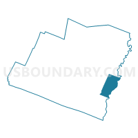
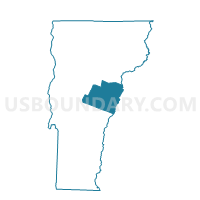
Fairlee Voting District, Orange County, Vermont
About
Outline

Summary
| Unique Area Identifier | 680836 |
| Name | Fairlee Voting District |
| County | Orange County |
| State | Vermont |
| Area (square miles) | 21.25 |
| Land Area (square miles) | 20.13 |
| Water Area (square miles) | 1.12 |
| % of Land Area | 94.75 |
| % of Water Area | 5.25 |
| Latitude of the Internal Point | 43.91784580 |
| Longtitude of the Internal Point | -72.18029640 |
Maps

Graphs
Select a template below for downloading or customizing gragh for Fairlee Voting District, Orange County, Vermont


Neighbors
Neighoring Voting District (by Name) Neighboring Voting District on the Map
- Bradford Voting District, Orange County, VT
- Thetford Voting District, Orange County, VT
- TOWN OF LYME Voting District, Grafton County, NH
- TOWN OF ORFORD Voting District, Grafton County, NH
- West Fairlee Voting District, Orange County, VT
Top 10 Neighboring County Subdivision (by Population) Neighboring County Subdivision on the Map
- Bradford town, Orange County, VT (2,797)
- Thetford town, Orange County, VT (2,588)
- Lyme town, Grafton County, NH (1,716)
- Orford town, Grafton County, NH (1,237)
- Fairlee town, Orange County, VT (977)
- West Fairlee town, Orange County, VT (652)
Top 10 Neighboring Place (by Population) Neighboring Place on the Map
Top 10 Neighboring Elementary School District (by Population) Neighboring Elementary School District on the Map
- Bradford Incorporated School District, VT (2,797)
- Thetford School District, VT (2,588)
- Lyme School District, NH (1,716)
Top 10 Neighboring Secondary School District (by Population) Neighboring Secondary School District on the Map
Top 10 Neighboring Unified School District (by Population) Neighboring Unified School District on the Map
Top 10 Neighboring State Legislative District Lower Chamber (by Population) Neighboring State Legislative District Lower Chamber on the Map
- State House District 9, Grafton County, NH (12,976)
- Windsor-Orange-2 State House District, VT (8,602)
- State House District 6, Grafton County, NH (7,044)
- Orange-2 State House District, VT (4,426)
Top 10 Neighboring State Legislative District Upper Chamber (by Population) Neighboring State Legislative District Upper Chamber on the Map
- State Senate District 2, NH (57,095)
- Caledonia State Senate District, VT (40,114)
- Orange State Senate District, VT (20,049)
Top 10 Neighboring 111th Congressional District (by Population) Neighboring 111th Congressional District on the Map
Top 10 Neighboring Census Tract (by Population) Neighboring Census Tract on the Map
- Census Tract 9609, Grafton County, NH (3,266)
- Census Tract 9607, Grafton County, NH (2,938)
- Census Tract 9598, Orange County, VT (2,797)
- Census Tract 9596, Orange County, VT (2,588)
- Census Tract 9597, Orange County, VT (1,629)